The maps behind the £60m
Morning traffic chaos, awkward Pride in Place boundaries, and Reform’s AI slop problem

A tunnel closure and a fire in Strood combined to ruin Medway’s morning commute, highlighting how quickly the area’s limited river crossings can come under pressure. We also examine the detail behind Medway’s £60m Pride in Place funding, where the official maps show a much tighter set of areas than the political messaging suggests, and look at Reform’s error-filled AI-generated guide to local government reorganisation.
Pride in Place
Three parts of Medway are now set to receive the full £20m each through the government’s Pride in Place programme, with Luton joining the two areas already being talked about in Strood and Twydall. Friday’s initial local messaging suggested Luton was set for a smaller allocation, but it has since been clarified that all three Medway areas are due to receive the full £20m.
That means Medway is in line for £60m in new Pride in Place funding over the next decade, one of the largest allocations given out nationally.
That is a bigger haul than it first appeared to be when the announcements started flying around on Friday. But the more interesting wrinkle now is not the money, but the map.
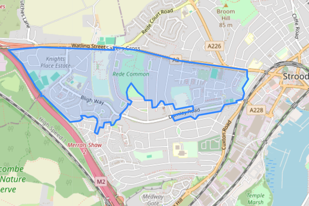
Because while politicians and the council have been talking about 'Strood,' 'Gillingham and Twydall' and 'Luton in Chatham,' the actual areas selected are much tighter than those labels suggest. The government did not pick whole towns or broad neighbourhoods. It picked three precise Middle-layer Super Output Areas called Rede Common, Twydall and Luton.
As a result, the three funded areas do not all line up neatly with how local people would describe them.
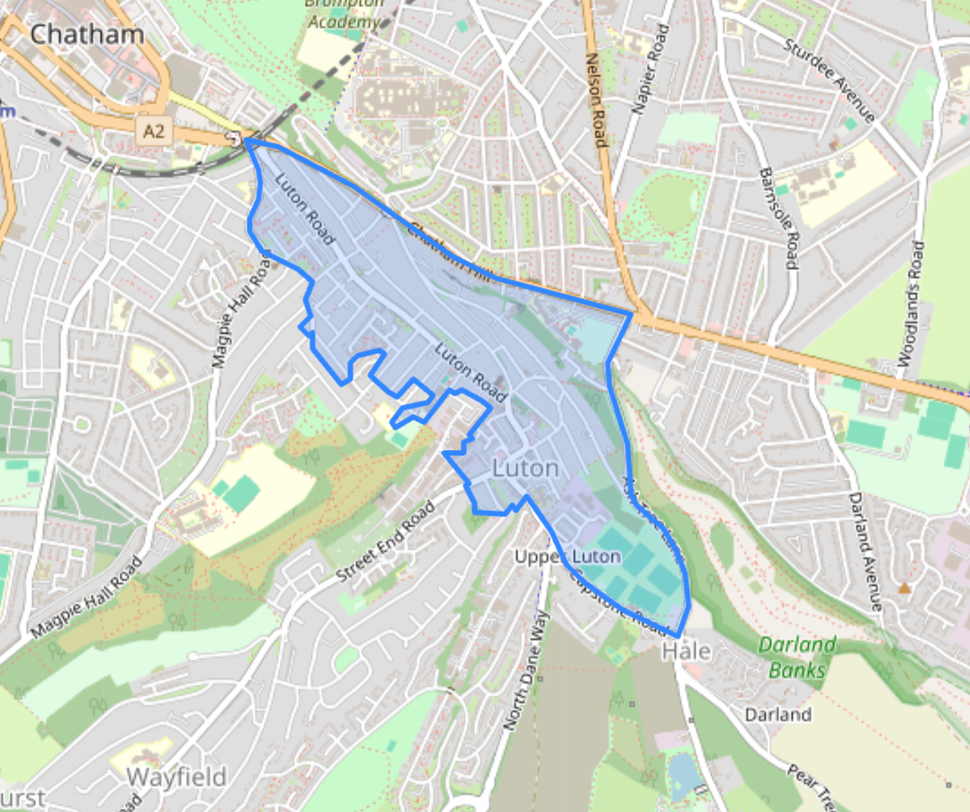
Luton is the least awkward of the three. On the map, it broadly looks like Luton as most Medway residents would understand it, running from Luton Arches through the heart of the neighbourhood and out towards the local centre at the eastern end. If one of the three areas can be described in simple shorthand without too much trouble, it is this one.
The other two are much less straightforward.
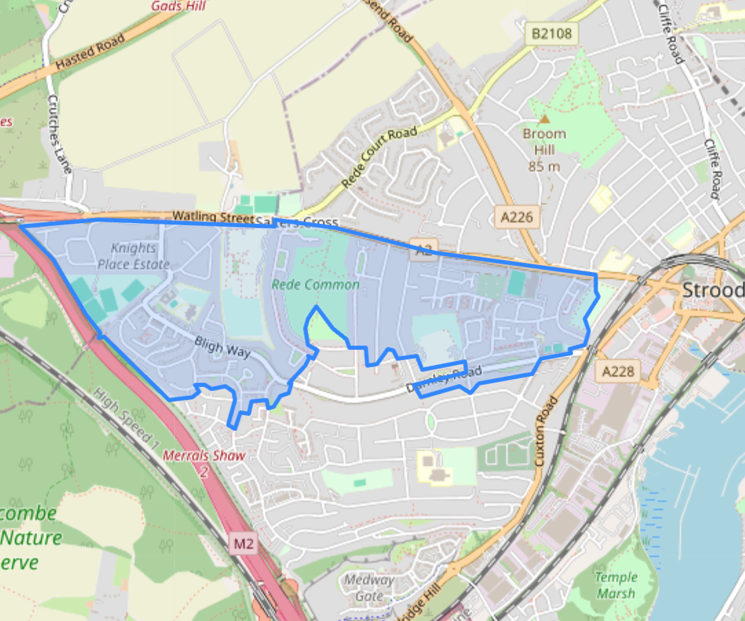
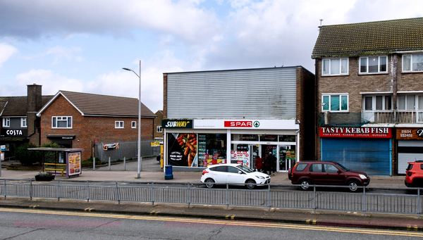
The area being presented politically as Strood is in fact Rede Common, a strip south of the A2 and west of Cuxton Road. It leaves out Strood town centre, the riverside and everything north of the A2. It also has some odd edges, cutting through residential streets in a way that makes sense as a statistical boundary but not much sense as a place people would naturally talk about. Darnley Road and Bligh Way, for example, include both ends, while the middle section is not.
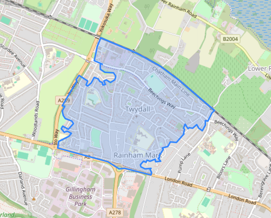
Twydall is similarly more limited than the shorthand being used around it. It is essentially Twydall, not 'Gillingham and Twydall' in any broader sense, and it is nowhere near Gillingham town centre. Once again, there are streets which most local people would obviously think of as Twydall that appear to fall outside the line.
That does not mean the money is not real. It clearly is. Nor does it mean those areas could not still benefit more broadly from the programme. But it does mean that some of the initial political messaging risked creating a broader impression than the maps really support.
Part of the explanation is that this programme starts from Whitehall’s map, not Medway’s mental one. The government’s methodology note makes clear that these areas are based on 2021 MSOAs, not broad town or neighbourhood identities. In plain English, they are statistical units first and communities second.
That helps explain the awkwardness of some of the boundaries. They were not drawn to reflect how people talk about places. They were drawn because that is how the programme selected eligible neighbourhoods.
There is, however, some wriggle room later. Government guidance says the Neighbourhood Boards for each area can ask the Ministry of Housing, Communities, and Local Government to alter the default boundary, as long as any new area fully contains the original one, stays contiguous and remains at neighbourhood scale. In other words, they cannot carve bits out, but they can seek to widen the area if there is a case for doing so. The guidance specifically mentions situations where a key asset or key street has been left just outside the line, though it is unclear exactly where it could benefit here.
Even without a formal boundary change, the same guidance allows some interventions to extend beyond the strict programme boundary where there is a clear rationale and the main benefit remains for residents within the funded area.
So the maps published now may not be the final practical footprint of what Pride in Place will ultimately touch. But it is the starting point, and it is much more precise than how the scheme is currently being discussed.
That matters because expectations are already being set. If residents hear that Strood has secured £20m, many will quite reasonably picture the High Street, the riverside or the wider town centre. If they hear Gillingham and Twydall, many will picture something much broader than the Twydall patch on the official map. At least for now, that is not what has been selected.
The money is at least a larger pot than it first appeared, even if the geography is smaller than some of the announcements suggest. As the Neighbourhood Boards begin to take shape, Medway’s next argument may not be over whether the funding is welcome, but over who is really inside the line.
Two closures before breakfast ruin the morning commute
One road closure is usually enough to bring Medway to a standstill. This morning, it got two.
The Medway Tunnel was shut after an overnight power failure left it unable to meet the legal safety requirements needed to stay open, while a fire at Ramo’s Cafe also closed part of Strood High Street in the early hours. Between them, one of Medway’s key cross-river routes was out, and one of the main alternative routes was disrupted before breakfast.
The tunnel isn't some minor bit of infrastructure. The 30 year old route under the river carries over 50,000 vehicles a day on average.
This is one of Medway’s built-in weaknesses. There are only so many meaningful ways across the river, so when the tunnel is out of action, the pressure lands almost instantly somewhere else, usually Rochester Bridge and the roads around it, which already struggle on a good day.
There was some early confusion over the closure after Medway Council posted on social media at around 6.20am saying the tunnel was shut in both directions, despite drivers still appearing to pass through later in the morning. The council says it put the message out as soon as it was told the tunnel would be closing, with traffic management then needing time to mobilise.
A Medway Council spokesperson said, “Following a power failure in the Medway Tunnel overnight, the team followed standard procedure to reset the tunnel systems, which fixed some but not all of the safety requirements. For example, the lights started to work, but the tunnel signage did not.”
“Under the Road Tunnel Safety Act 2007, tunnels have minimal operational safety requirements which have to be met in order to be open. Therefore the Medway Tunnel has had to be closed.”
“Engineers are currently on site, with specialists also en route. We anticipate the tunnel will be closed for at least most of today (Tuesday, 24 March), and will update residents on our social media channels as soon as we have more information.” Happily, the tunnel reopened around 1pm, avoiding any repeat scenes on the evening commute.
The council's explanation helps explain why some drivers reported seeing the tunnel lit as normal before the closure. The issue, the council says, was not that everything was dead, but that enough of the safety system remained out to make keeping it open unlawful.
The disruption was then worsened by the fire in Strood. Kent Fire and Rescue Service said it was called to a commercial building fire on High Street at around 4am, eventually sending seven fire engines and a height vehicle. The road was closed due to smoke before reopening around 7.30am, while crews continued tackling the blaze from the rear of the building. An investigation into the cause is underway.
Taken separately, either incident would have caused problems. Together, they were enough to tip a fragile road network into the kind of traffic misery Medway knows all too well.
Reform's adventures in AI slop
There is bad political design, and then there is this.
Reform Rochester and Strood published an image on it's Facebook page last week that tries to be a guide to local government reorganisation in Kent and Medway. In practice, it is AI slop that is error strewn, half baked, and so badly put together that anyone relying on it would come away less informed than when they started.
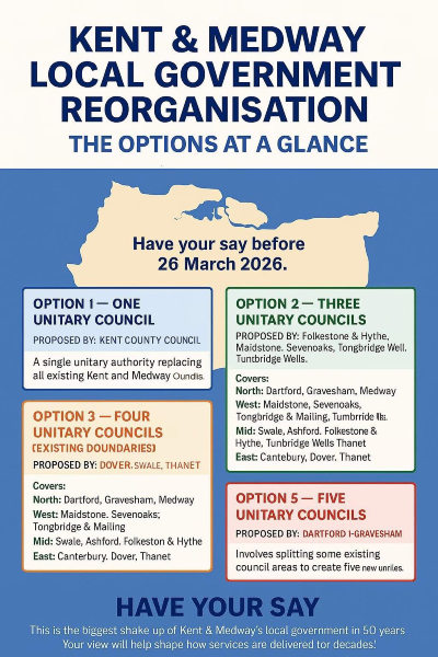
The obvious problems leap off the screen. There are spelling and text failures, including “Oundlis,” “Tongbridge Well,” “Tumbrride,” and the promise that public feedback will help shape services “tor decades.” There is a strange jump in numbering, with no Option 4 at all. Even at the level of basic presentation, it looks like something churned out in minutes and posted without anyone bothering to check it.
But the real issue is not that it looks ridiculous. It is that it is wrong.
Most glaringly, the poster does not include the 4D option, the proposal being pushed by Medway and backed by Canterbury and Ashford. This is not some obscure side argument that can reasonably be left out of a simplified explainer. It is one of the live options in the debate. If you are asking residents to “have your say” on the future structure of local government, omitting one of the actual proposals is not a minor slip. It makes the entire graphic substantially misleading.
What remains is no better. The options that do appear either leave out important information or include information that is simply incorrect. Even if a reader generously ignored the mangled text, ropey design, and obvious AI stink coming off the whole thing, they still wouldn't get a reliable guide to the choices on the table.
That matters because local government reorganisation is not a trivial process point. It will shape how hundreds of thousands of people across Kent and Medway are governed, how services are run, where power sits and who makes key decisions for years to come. It is complicated enough already without political parties pumping low-grade misinformation into the discussion.
This is not a cheap joke at the expense of ugly design, or an argument that nobody should ever use AI tools. It is about standards. If a party wants to posture as a serious insurgent force ready to reshape local government, the least it can do is ensure its explainer presents the real options and gets the basic facts right.
Instead, Reform has produced a poster that is both visually absurd and substantively unreliable. It is AI slop masquerading as political communication.
If Reform wants to be taken seriously on the future of local government, it should start by showing it understands the present debate.
Footnotes
Follow us on social media! We’re on Facebook, Instagram, and BlueSky, but not that other one.