More School Streets confirmed
Nine new areas face camera restrictions, Medway's 'London-style' bus network, some good data visualisation, news in brief, and more
If we’ve learnt one thing about Medway’s Labour administration, it’s that they are big fans of enforcement cameras. This week, Medway’s Cabinet has signed off on the next set of School Streets in our towns despite another consultation that didn’t support them. Further down, news on a big investment into Medway’s bus services, a nice bit of data visualisation, news in brief, and more.
More School Streets confirmed
Nine more School Streets are set to launch in Medway after Medway Council’s cabinet agreed to progress the scheme at tonight’s meeting.
Following an informal consultation in recent months, it was unsurprisingly deemed appropriate to advance all nine schemes, albeit with some tweaks to three. We won’t rehash all the proposals here, but some were slightly odd, as we highlighted back in September.
Still, the scheme does have merits, and anything that makes the streets around a school safer and more pleasant for pedestrians and residents should be welcomed. Streets from the first tranche of the scheme are proving to be fruitful earners for Medway Council, too, with 2,000 fines issued in the first six months.
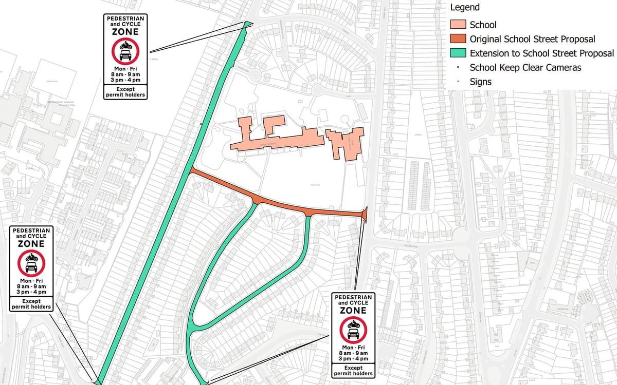
So, what changes have been made to the proposed new School Streets following the consultation? Three have been much larger than originally planned. One, around Horsted Infant and Junior School, adds a logical street, but two others in Rochester dramatically change the scope of the scheme.
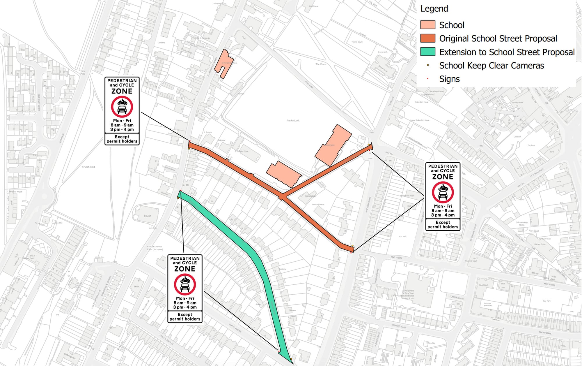
Take the scheme around King’s in Rochester, which manages to add an entire street that doesn’t connect to the existing streets around the school. There is a rational reason for it, given there is a pedestrian footpath between the newly added Roebuck Road and the existing scheme, presuming meaning parents may well try and drop their children off there. But it remains slightly odd to add an exclave street, while not including St. Margaret’s Street, which suffers from significant King’s congestion and has one of the entrances to the school. Another potential issue is that Watts Avenue is frequently congested thanks to St. Andrew’s school traffic, with Roebuck Road acting as an informal one-way system to navigate the area. It will be interesting to see how this is distributed under the new scheme.

Things get even more dramatic around Delce Academy, where an initial plan to implement the scheme on just one street has been expanded to cover a vast swathe of The Tideway and surrounding streets. This takes the scheme well beyond the scale seen in the first tranche and presumably will relocate large amounts of traffic to the east side of The Tideway instead.
Of course, these are, in the grand scheme of things, relatively minor niggles. The system will presumably bed in, and evidence from the initial streets shows that the number of drivers entering the area when they shouldn’t have has been decreasing with time.
The process does follow the increasingly regular pattern of consultations that don’t mean a great deal. The data from the consultation has been presented in an almost impenetrable way, which seems to be because the data suggests that most respondents were against the scheme. While residents within some of the zones are understandably in favour, school staff seem split on the issue, with parents and other residents being primarily against. Indeed, one scheme - Fairview Primary in Rainham - saw all groups against the scheme by a large margin, but they’ll be getting it anyway.
Now, there is an argument for doing this regardless. Policy and action shouldn’t only be taken when popular, and the existing streets in the scheme seem to have been received fairly well despite doubts beforehand. There is also merit in holding consultations to find improvements and tweaks to the scheme, as portfolio holder Cllr Alex Paterson suggested in tonight’s meeting. However, asking residents if they agree with the scheme and then entirely disregarding their answers does not seem to be the best way to bring people with you, however well-intentioned the scheme may be.
What does a ‘London-style’ bus service look like in Medway?
The government invested significantly in bus services last week, throwing £1bn around the country to offer ‘once-in-a-generation reform to deliver London-style bus services to every corner of the country.’
Now, if you’re like us, you might wonder exactly what a ‘London-style’ bus service in Medway might look like.
We can probably assume it won’t mean all fares cost £1.75, or that buses arrive every few minutes. It’s also hard to imagine buses running across our towns throughout the night. So what does the term really mean?
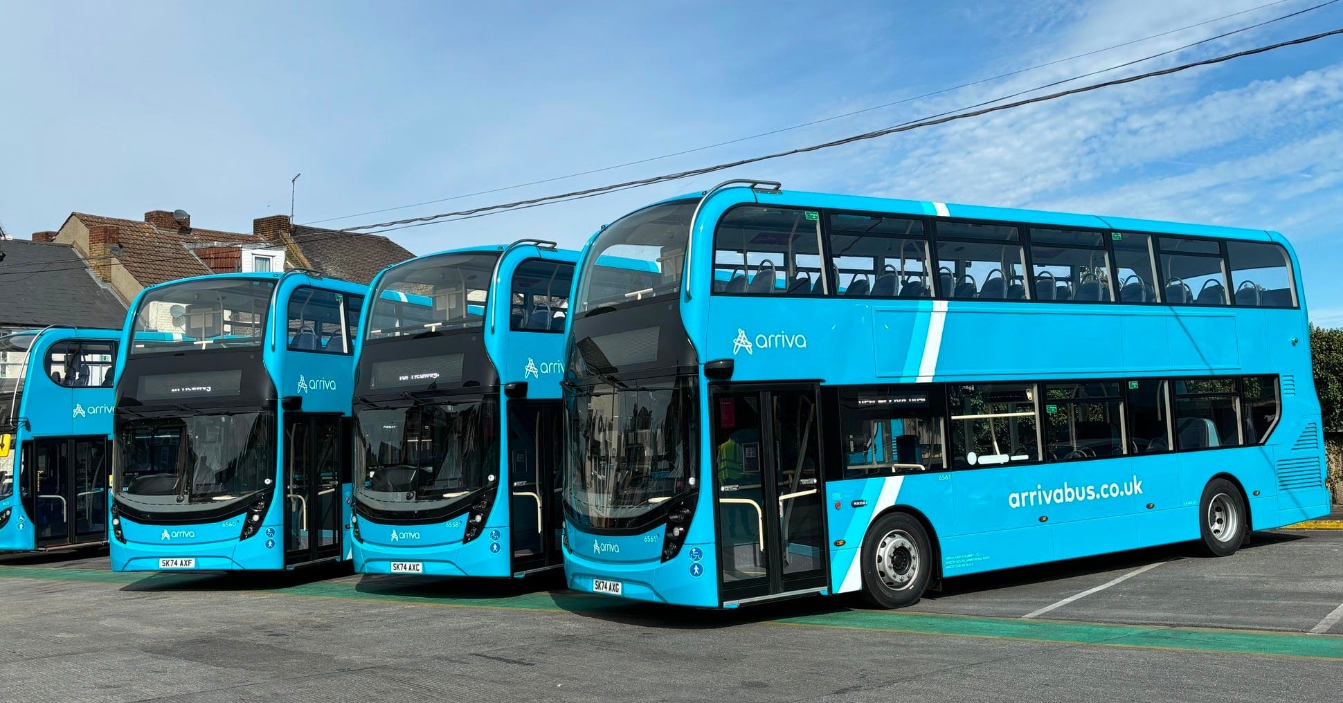
The most likely explanation is that ‘London-style’ is just shorthand for buses that are actually quite good. Buses that run regularly and reliably and don’t cost a fortune.
Medway is being allocated £2.6m in capital funding for long-term bus projects and £1.1m for shorter-term ones. Further, our area will also receive £94,000 in ‘capacity and capability allocation’, with another £172,000 in bus operator’s grants to maintain existing services.
That’s the best part of £4m for bus services in Medway, which dwarfs the £760,000 received for 2024/25.
With over five times the money coming next year, what could Medway spend it on?
The possibilities are almost endless given these sorts of figures. While Medway’s previous Bus Service Improvement Plan was fairly uninspired, it did manage to do quite a lot with its previous allocation. Last year, funding was spent on repairing bus shelters, adding lights, running free bus weekends, and working out how to unify ticketing across Medway’s buses.
We’ve long talked about the poor state of Medway’s bus network and the work that needs to be done to improve it. This funding could offer a big first step in the right direction, but as ever, the devil will be in the detail.
Data visualisation is cool
We regularly talk about Medway Council’s finances here, but the numbers can often be so large that it’s hard to truly comprehend them. While we’d like to think our reporting helps, having data in a clear and easy to understand manner is incredibly valuable.
Sadly, Medway Council don’t make that sort of thing easily available. While councils, including Medway, have generally been better at explaining the figures involved, it is usually very dry, such as on this page on their website. It sets out where the £578m it has received this year comes from and what it will be spent on, but it’s just a list of numbers.
The latest edition of Medway Matters magazine, the council’s propaganda organ, presented the same data in pie chart form, with one showing the money in and one showing the money out, but kept the two separate. An improvement on the above, perhaps, but still not hugely straightforward to understand.
In light of all this, we were delighted to have this diagram below arrive in our inbox this week, courtesy of Phil Quinn, who has taken it upon himself to visualise it in a way the council has never managed.
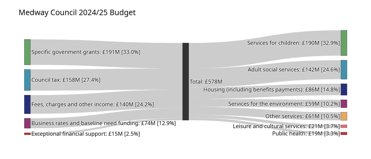
Data nerds will recognise this as a Sankey diagram, though we hadn’t heard of them until today. It’s a good way of understanding how much Medway has coming in and where it all ends up. For all of the stories about the Exceptional Financial Support request last year, it represents just 2.5% of the budget and wouldn’t even cover a tenth of the adult social care budget.
Elsewhere, it’s striking that the government grant, which has declined massively since 2010, now only just about covers children’s services and absolutely nothing else. Councils increasingly have to find revenue elsewhere, with the fees and charges section growing most notably.
Anyway, there’s no great insight here beyond us thinking the diagram above is kind of cool. Phil has also made the code that generated the chart available here if you want to play around with your versions.
Hooray for data!
In brief
🚄 Southeastern will operate a new timetable from 14 December. While changes are being made across the wider network, there appears to be no change to services to and from Medway.
🏠 Some Gillingham residents are fighting a house on their road being converted to a House of Multiple Occupation (HMO). These battles will likely become more regular as HMOs are increasingly used to relieve our housing crisis.
🛒 B&M in Gillingham opened on Saturday. The discount retailer has taken over the former Wilko unit in Gillingham High Street.
👷 Dockside Outlet Centre has requested planning permission to subdivide the Clarks unit. Two new units would be created, both of which could be accessed externally outside of centre hours, suggesting the intent is for hospitality or leisure use.
More Authority
For our weekend interview, Steven sat down with senior lecturer and doctoral candidate Tom Delahunt to discuss how the arts can help with trauma, his work, and his children’s books.

Footnotes
Not to go all Guardian on you, but we departed the site formerly known as Twitter this week. If you’d like to follow us socially, we’re still active on Facebook, BlueSky, Instagram, and Threads.
If you enjoy Local Authority, please share it with your friends, family, associates, and enemies. We have no meaningful marketing budget, so we rely on word of mouth from our readers to find new readers. You can even get some sweet rewards for sending new readers our way. Details here.
Music that soundtracked the creation of this edition: More Hell by Los Campesinos!, Tourist In This Town by Allison Crutchfield, and How To Be Hopeful by Johnny Foreigner.


